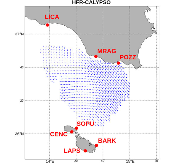
HFR-CALYPSO
HFR system name:
HFR-CALYSPO
Spatial location:
Malta Channel
Sites (frequency):
BARK (13.5 MHz), CENC (13.5 MHz), LAPS (13.5 MHz), LICA (13.5 MHz), MRAG (13.5 MHz), POZZ (13.5 MHz), SOPU (13.5 MHz)
Manufacturer:
CODAR
Owning institution:
University of Malta / University of Palermo / ARPA Sicilia / CNR-IAS
Operating institution:
University of Malta / University of Palermo / ARPA Sicilia / CNR-IAS
EDMO code:
708
Contact names:
Adam Gauci, Giuseppe Ciraolo, Fulvio Capodici
Contact emails:
adam.gauci@um.edu.mt; giuseppe.ciraolo@unipa.it; fulvio.capodici@unipa.it
DOI:
Time coverage:
2022 - present
Description:
The CALYPSO system is an operational network of High Frequency (HF) radars, based on CODAR SeaSonde technology, that provides real-time maps of sea surface currents across the dynamically active Malta–Sicily Channel. The initial CALYPSO project established three radar stations at Ta’ Barkat (Malta), Ta’ Sopu (Gozo), and Pozzallo Harbour (Sicily). These combine their radial measurements to generate hourly current vectors on a regular grid using a 13.5 MHz operating frequency. Follow-up initiatives, notably CALYPSO South, expanded the network to seven sites, extending the monitoring footprint to cover the entire Maltese marine area and south-eastern Sicily, with a total expected coverage of around 15,000 square kilometres. Beyond environmental protection, the high-resolution data support search and rescue (SAR) operations, help identify the origin of marine spills, contribute to safer navigation, and improve meteo-marine forecasts for the responsible authorities in Malta and Sicily.
Publications:
- Drago, A., Ciraolo, G., Capodici, F., Cosoli, S., Gacic, M., Poulain, P.M., Tarasova, R., Azzopardi, J., Gauci, A., Maltese, A. and Nasello, C., 2014. CALYPSO an operational network of HF radars for the Malta-Sicily Channel.
- Capodici, F., Cosoli, S., Ciraolo, G., Nasello, C., Maltese, A., Poulain, P.M., Drago, A., Azzopardi, J. and Gauci, A., 2019. Validation of HF radar sea surface currents in the Malta-Sicily Channel. Remote sensing of environment, 225, pp.65-76.
- Gauci, A., Drago, A. and Abela, J., 2016. Gap filling of the calypso hf radar sea surface current data through past measurements and satellite wind observations. International Journal of Navigation and Observation, 2016(1), p.2605198.


INTERREG VA Italy-Malta
The success and continuity of the CALYPSO High Frequency (HF) radar network are largely due to the sustained effort and institutional support of its core academic partners. Prof. Aldo Drago led the CALYPSO and CALYPSO South projects, a role reinforced by the cross-border collaboration between the University of Malta and the Università degli Studi di Palermo. This joint commitment underpins the network’s continuous operation and the provision of high-resolution, hourly sea surface current maps that support maritime safety and environmental protection in the Malta–Sicily Channel.